Contents:
Section I — INTRODUCTION & FOUNDATION
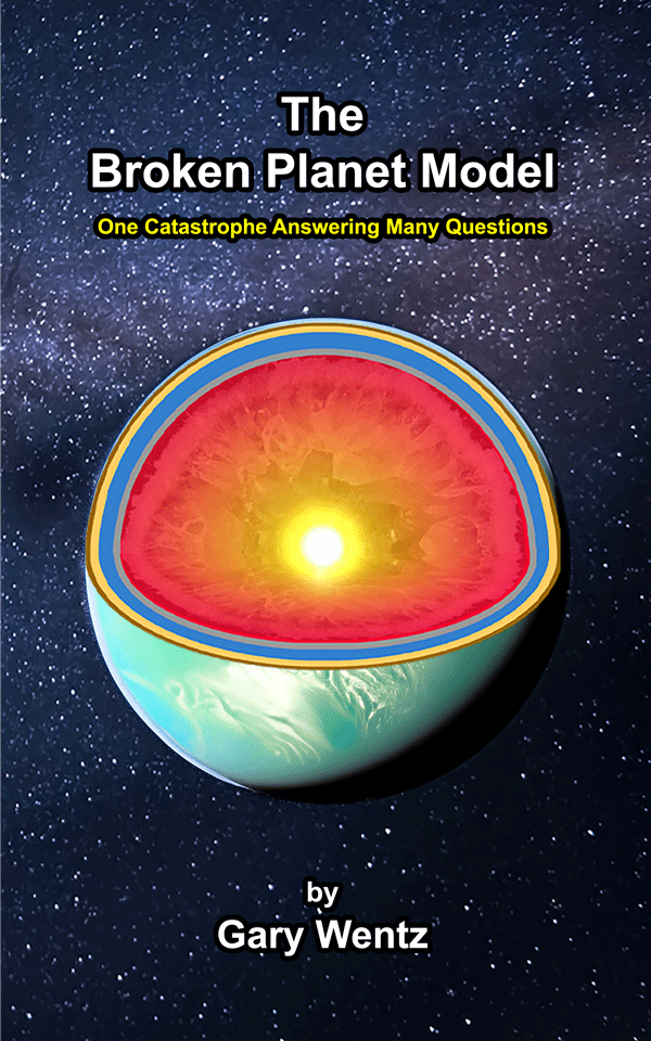
Section II — PRE-FLOOD STRUCTURE OF THE EARTH
Section III — CATASTROPHE – THE BROKEN PLANET
Section IV — SCIENTIFIC RAMIFICATIONS OF THE MODEL
Section V — SCIENTIFIC PREDICTIONS & FUTURE RESEARCH
Appendix A: Effects of the BPM Across All Disciplines
Appendix B: BPM Summary and Scientific Impact
Appendix C: Scientific Predictions of the Broken Planet Model (BPM)
SECTION IV: SCIENTIFIC RAMIFICATIONS OF THE MODEL
Introduction
The Broken Planet Model presents a radically different approach to Earth’s geological history, challenging the assumptions of deep time, uniformitarian geology, and conventional plate tectonics. If the Flood was a cataclysmic, one-time event, then it must have left behind clear, global-scale geological signatures that we can observe today.
This section will examine the scientific consequences of the model, addressing:
• The formation of continents, islands, mountains, and canyons as direct outcomes of Flood-related forces.
• The recession of Floodwaters, filling oceans, rivers, and inland lakes.
• The impact of radiation contamination and its role in reduced lifespans, genetic degradation, and environmental changes.
• The post-Flood fossil record and how it aligns with rapid burial, fossil fuel formation, and observable anomalies like polystrate fossils and “living fossils.”
• The dispersal of human civilization after the Flood, as populations adapted to a dynamic, new world.
This model rejects deep-time interpretations of geological and anthropological history, instead proposing a scientifically robust, biblically consistent alternative that explains Earth’s features as the direct result of the Flood’s immense forces.
As we move forward, we will explore the unmistakable evidence of these world-changing processes and how they reshape our understanding of geology, paleontology, and human history.
New Geological Features and Topography
Formation of Continents & Islands
The formation of Earth’s continents and islands was a direct result of catastrophic hydrological and geological forces unleashed during the Flood. As the Bedrock Layer collapsed, the vast subterranean Water Layer was violently expelled, generating immense pressure that reshaped the planet’s surface. This powerful movement worked upon lava flows, mud deposition, and sediment redistribution, rapidly forming the landmasses we see today.
Hydrological Forces—The Driving Mechanism
The most critical force at play was the massive displacement of water as the collapsing Bedrock Layer forced it upward and outward from beneath. This expulsion of water did not happen gradually but in a violent, pressurized surge, creating turbulent flows across the entire surface of the Earth. The force of this movement had profound geological effects, including the instant saturation of pre-Flood soil, which transformed into a global slurry of mud and sediment. This fluidized mixture of water and earth covered vast areas, allowing mud to be transported and redeposited rapidly across the landscape.
Rather than slow, uniform deposition over eons, this high-energy process resulted in chaotic, large-scale sediment transport and sorting. Mud did not settle neatly but was instead forcefully carried into position, with water acting as both a transporter and a pressurizing agent. The sheer force of this hydraulic activity compressed layers, folded sediments, and set the stage for the rapid lithification of new landmasses in combination with immense heat.
Lava Foundations—The Base of the Continents
As the Bedrock Layer fractured, massive quantities of lava from the Mantle surged through these newly created fissures. Unlike the lightweight, water-saturated mud, lava is far denser, and thus, it naturally settled first in the lowest regions, creating the structural foundation for the developing continents.
The rapid escape of lava was not a slow, volcanic process as seen today but rather a one-time event of immense magnitude, driven by the breaking apart of Earth’s Mantle and crust. As the lava flowed outward, it adhered to the plate surfaces, solidifying quickly upon exposure to the cooler atmosphere or surrounding water. This cooling process formed the deep igneous base upon which the continents rest today.
The density difference between lava and mud ensured that the heavier lava settled first, forming a sturdy bedrock layer, while the lighter mud and sediment remained suspended in water, awaiting final deposition. The foundation of the continents, therefore, was established in a matter of days or weeks, not over millions of years.
Mud Baked into Sedimentary Rock Layers
With the lava forming the base, the remaining suspended mud and sediment in the turbulent waters were violently forced into place atop the newly formed igneous foundations. The combination of hydraulic pressure, water displacement, and residual heat from the escaping lava caused this mud to rapidly harden into sedimentary rock layers.
The extreme heat released by the lava accelerated water evaporation from the saturated mud layers, promoting rapid lithification. In areas where additional pressure was applied—either by subsequent layering, plate movement, or shifting water weight—certain sedimentary layers were further altered, leading to the formation of bent rock strata and early-stage metamorphic rock.
Many of these layers were still soft and not fully consolidated when subjected to external forces, which explains why many bent rock formations around the world show smooth, unbroken folds rather than fractured, brittle breaks. However, some formations were mostly solid, creating broken and jagged edges, cracks, depressions, or uplifts when acted upon by much force. In traditional geology, such folds are assumed to form over long ages under slow deformation, but the evidence of soft-sediment folding aligns precisely with the rapid events described by the BPM Flood Model. As do the same forces acting on more hardened sheets developing more jagged formations.
Additionally, the immense heat and pressure from the settling landmasses and accompanying lava led to the early formation of metamorphic rock in key regions. This transformation process, which is commonly thought to take millions of years, instead occurred within weeks or months under the extreme conditions of the Flood’s aftermath. Where textbooks show 600 million years for such processes, the model shows that even as many days is too long.
Conclusion
The hydrological forces of water displacement, the density-driven settling of lava, and the rapid lithification of mud into sedimentary rock layers formed the continents and islands in a matter of days (no more than 150). The broken remnants of the Bedrock Layer became tectonic plates, while the water-logged mud solidified into the vast sedimentary rock layers seen across the world today. This process fully accounts for the structure of the continents and the layering of the crust without requiring slow, deep-time assumptions or uniformitarian processes.
| Key Points: Continents were formed by lava escaping the Mantle and forming on top of the fractured plates of the former Bedrock. When the mud from the Soil Layer contacted the lava it remained in place and baked into sedimentary rock layers. The mud and lava atop the plates was moved into place by water surges powered by the force of plates descending onto the Mantle. If moved together, the lava is heavier than the mud and therefore stayed on the bottom, contacting and adhering to the top of the fallen plates. Before this process of the Flood’s dynamics, continents did not exist. |
Mountain Ranges Formed by Tsunamic Activity
The formation of mountain ranges in the Broken Planet Model was not the result of slow, gradual uplift over millions of years, but rather a sudden and catastrophic process driven by immense hydrological forces, rapid landmass collisions, and dynamic uplift. As the Bedrock Layer collapsed, water surged outward, generating mega tsunami-scale waves that displaced vast amounts of mud, rock, and debris. However, the mountains did not form from water erosion or deposition—they were the result of landmasses colliding, stacking, folding, wrinkling, and being rapidly uplifted under extreme forces.
Pre-Lithified Layers & the Wrinkling Effect
Before being lifted into towering peaks, many sedimentary layers were already partially lithified due to the immense pressure, heat, and water displacement from the Flood’s earliest moments. These layers were not fully hardened, but neither were they loose, unconsolidated mud—they were in a transitional state, allowing them to be dramatically deformed without breaking apart into rubble.
• This partially set state explains why some mountain ranges have intensely folded layers rather than shattered rock formations.
• The degree of lithification determined whether uplifted mountains became jagged peaks or exhibited sloped, asymmetric formations.
• In cases where multiple mud mats were already in place, additional landmasses were forced into them, causing the compression, stacking, and wrinkling effect seen in many modern ranges. This was likely a later stage after much layering had already taken place.
Landmass Collisions & the Formation of Modern Ranges
The Western U.S. mountain ranges provide an excellent example of this process. The land east of the Rocky Mountains had already formed and settled before a second mass of sediment-laden terrain collided with it.
• Since the eastern landmass remained stationary, the incoming landmass was forced upward and compressed, creating the dramatic uplift of the Rockies, the Cascades, and the Sierra Nevada ranges.
• This collision-driven uplift explains why many mountain ranges feature steep cliffs on one side and gradual slopes on the other—the result of one side being forced upward while the other remained in place.
Rather than millions of years of slow orogenic uplift, these mountains were raised in days and weeks, as water pressure, sediment displacement, and rapid lithification locked them into place.
| Key Points: When the water of the Flood pushed one huge mud mat into another—and both were partially hardened—wrinkles formed in the collision. These wrinkles are mountains. When the mud that was moved from where the Pacific Ocean is now collided with the land already in place, from the plains of America eastward, that is when the Rockies, Sierras, and Cascades were formed. This shows how powerful the water movements were in the Great Flood. |
Canyons Formed by Forces Acting on Partially Hardened Layers
The Broken Planet Model rejects the idea that canyons formed by slow erosion over millions of years. Instead, canyons were rapidly formed before the Floodwaters drained, as landmasses shifted, and underground voids collapsed.
In all cases, the rising, falling, and colliding of landmasses played a greater role than erosion. The Grand Canyon is a prime example. The interior locations of the canyon are at a higher elevation than the perimeter, indicating that it was forced upward from beneath. That upward lift is what caused the already hardened mass to crack. How advanced the hardening was needs research.
• As water drained from the higher elevations, it exposed underlying sediment layers that had already undergone partial lithification and fracturing.
• Uplift from below raised the region, or impact from the side caused fractures, and allowed water to cut through these exposed layers rapidly, causing some erosion.
• Rather than a slow meandering river gradually deepening the canyon, the process was catastrophic and sudden, creating the immense depth and structure of the Grand Canyon in weeks or months. In some cases where soft sediment remained in the bottom, the water carved the sediment layer to a degree.
The forces that shaped the canyons of the world were primarily upward pressure, tectonic pulling apart, and water-assisted sediment removal—not slow, gradual river erosion of the entire formation.
Volcanism—A Residual Effect of the Flood’s Aftermath
The massive fracturing of the Earth’s Bedrock during the Flood did not only release water—it also unleashed enormous amounts of lava, reshaping the sedimentary surface through volcanic activity that continues to this day. While some volcanoes are directly connected to deep Mantle flows, others formed by an entirely different process—one that involves lava being displaced and moved along with sediment layers.
Two Types of Post-Flood Volcanism
Active Volcanoes with Direct Mantle Connections
• These volcanoes formed where deep fractures allowed lava to continue flowing from the Mantle to the surface.
• They remain active today because their connections to Earth’s interior remain unbroken.
• Examples: Ring of Fire volcanoes, Hawaiian hot spots, and Icelandic plumes.
Dormant Volcanoes Created by Sediment-Driven Displacement
• Some lava was forcibly moved along with the mud layers and trapped within sedimentary deposits through which it exuded.
• This displaced lava was forced upward, erupting onto the surface, forming volcano-like structures.
• However, since these volcanoes were not connected to deep Mantle flows, they quickly became dormant once the internal pressure dissipated.
• These features resemble active volcanoes but no longer have deep lava plumes or magma chambers.
This explains why some volcanic regions show evidence of extensive lava flows, yet are no longer geologically active. These features were the result of Flood-driven lava displacement, rather than long-term volcanic processes through plumes connected to lower regions of massive lava deposits.
| Key Points: The same forces that created mountains also formed huge canyons in places. The Grand Canyon was likely formed when the land it is made of was lifted by these huge forces after it had hardened some. This lifting caused the cracks that we call a canyon. In other places, the land may have fallen out, like in a sinkhole. Either way, or by collision, it was not water moving in a river that caused the canyons, it was movement of the land masses that were partially or completely hardened that made the huge cracks in the new landforms. |
Ocean Formation
The oceans of today did not exist in their current form before the Flood. The pre-Flood world was a single, unbroken landmass, resting atop the Bedrock Layer, which in turn sealed off the vast Water Layer beneath it. The Flood began when this Bedrock Layer catastrophically fractured, causing the entire structure to collapse, and as a result, the water was violently released onto the surface.
However, the formation of the oceans was not simply a matter of Floodwaters subsiding—it was a consequence of the continents rising. As large sections of land were forced upward, the displaced water had no choice but to recede into the newly exposed regions of the fallen Bedrock Layer. What we now call the ocean floors are not mere depressions but the remnants of where the Bedrock Layer fell and settled onto the Mantle.
This process alone accounts for the staggering depth of modern oceans. The idea that oceans were carved over millions of years does not hold up against the sheer structural shift that occurred in a matter of weeks. As the rising continents emerged, the water naturally pooled into the lowest available areas—which happened to be the locations where the Bedrock Layer collapsed inward, exposing vast areas to Bedrock resting directly upon the Mantle.
The salinity of the oceans is another feature that was fundamentally different in the pre-Flood world. Before the collapse, the Water Layer was overwhelmingly fresh, but as the Flood reshaped the Earth, the water picked up mineral content from the exposed Mantle, lava flows, and chemically active rock layers. This process rapidly infused the oceans with dissolved minerals, leading to the salty composition observed today.
In this model, the oceans are not the result of gradual, uniform processes but the inevitable consequence of a one-time, catastrophic restructuring of Earth’s surface. Their depth, extent, and composition are all exactly what we would expect if the continents had risen and the water settled into the fallen Bedrock Layer.
| Key Points: Deep oceans did not exist before the Flood—only some shallow seas, lakes and rivers. Most water was in the Water Layer, deep underground. When the water came out of the Water Layer, the land that covered it fell below the waterline. But luckily for us, God raised up more land from the soil of that land and mixed it with the lava that was deep underground and coming out on top of the Bedrock. Since water always finds the lowest point, it ran off of the new continents that raised up and flowed to the deepest parts where land was not raised up. This explains where the water came from for the Flood and where it went to after it. |
Erosion of Top Layers
The post-Flood world was subject to rapid, large-scale erosion, not over millions of years, but in the immediate aftermath as the retreating waters scoured the landscape. This was not a slow, gentle process but a high-energy, high-speed reshaping of the planet’s surface.
One of the most striking results of this event was the formation of the continental shelf. This submerged extension of the continents does not reflect gradual sinking over eons, but rather, it represents the remnants of the land that was violently eroded and dragged away into deeper ocean basins. The edges of the continents appear as if they were cut cleanly off—not from slow, steady coastal erosion, but from the immense forces of water drainage, sediment removal, and landmass collapse.
Another major feature of this erosion is striations—long, deep scratches on exposed rock surfaces. Conventional geology often attributes these to glacial movement, but this explanation is problematic. How could slow-moving glaciers carve deep grooves into solid rock? Ice, even when laden with debris, lacks the necessary force to create such sharply defined, extensive cuts. The most logical explanation is that these striations were carved by high-speed water flow, moving with such intensity that entire layers of sediment and rock were rapidly stripped away.
The scale, depth, and directional alignment of these features suggest that they were formed by a single, planet-wide drainage event, rather than local, glacial activity spread out over ages. The sheer volume of water moving over the landscape acted as an abrasive force, dragging sediment, carving channels, and leaving behind evidence of rapid catastrophic erosion.
Rather than requiring long timescales, the erosion of the upper layers was immediate, leaving behind a world that bears the scars of a global flood, not slow, uniform changes.
| Key Points: Now that you know how the continents and mountains were formed, consider that the top layers of mud weren’t covered by more mud. But the water was still in motion. When the final water washed away from the tops of the continents, it took a lot of mud and rock with it into the new ocean beds. As the mud and rock washed into the new oceans, the Continental Shelf was formed all around the world. This final draining process left scars on the new and still soft rocks that remained as the rocks being washed away were dragged across those rocks that stayed. These scars are wrongly called Glacial Scars, when really they are Flood Scars. |
Post-Flood Drainage & Recession of Waters
As the continents rose and settled into place, the remaining Floodwaters had to retreat, seeking the lowest available areas. The process of drainage and water recession was the final stage in the restructuring of the Earth’s surface, forming lakes, continental seas, and the river systems we see today.
Inland lakes were created where water pooled in newly formed basins, trapped by the elevated terrain surrounding them. These lakes were not remnants of an ancient glacial period, but rather, short-lived water bodies that were either drained, evaporated, or stabilized into the lakes we recognize today. Some of the largest lakes in history, such as Lake Agassiz, are best understood as temporary post-Flood reservoirs that eventually broke through natural barriers and drained away.
Continental seas, covering vast portions of the interior land, remained for longer periods. These were not evidence of an ancient inland ocean, but rather the last remnants of Floodwaters slowly receding as the continents adjusted. Their rapid reduction in size accounts for the fossilized marine life found deep within continental interiors, where entire ecosystems were trapped in receding waters and buried under newly forming sediment layers.
The formation of modern river systems was also a byproduct of the Flood’s drainage. Many of the major river valleys—such as the Amazon, Nile, and Mississippi—were carved rapidly as water rushed to escape higher elevations. These channels were not eroded over millions of years by small streams but were initially formed by high-volume torrents of water moving at immense speeds.
A key indicator of this is that many modern rivers are underfit for their valleys—meaning that the current water flow is far too small to have carved out the channel it occupies. The only logical explanation is that these valleys were initially formed by a single, catastrophic drainage event, after which the smaller, modern rivers settled into the pre-carved pathways left behind.
The recession of the Floodwaters was the final act of reshaping the world, leaving behind lakes, seas, rivers, and erosion scars as lasting evidence of a catastrophe unlike anything seen since. These formations were not the result of slow natural processes but the direct consequences of a one-time, planet-altering event that reset the surface of the Earth.
| Key Points: As the final movement of water to the oceans occurred, some water was caught in places on the land. Some of these places were high in the mountains and some were in low lying areas. As the Earth continued to move and the wind blew very hard, much of this water was released from where it was captured and eventually went to the oceans with the rest. Water did not carve valleys and canyons when this happened, it just followed the lowest contours of the land. Where rivers remain, there is a reason why the water is still moving. If we look into this, we will see that some of the water is still in basins or bowls naturally made during the Flood where the water is still captured. Other rivers are the result of rain or snow runoff from higher elevations. The only places where water has carved the land is in the lowest places where it runs today. Those valleys and canyons were made by the movement of the land, but the water just goes through the lowest parts. So don’t think that water carved the great canyons and valleys—it’s just flowing through the bottoms of them. |
Water Table: Contamination & Depletion
The post-Flood world experienced significant changes in how water moved through the Earth, particularly in relation to the water table—the underground reservoirs and aquifers that sustain ecosystems and human life. Unlike the pre-Flood world, where water was stored in the vast subterranean Water Layer, the modern water table is a fragmented, incomplete system, existing in porous rock layers, underground lakes, and channels left behind by the catastrophe.
However, it is likely that the pre-Flood world also had a water table, but unlike today’s discontinuous and varied systems, it was continuous around the globe, with far less variation due to elevation and rock composition. More importantly, it was connected to the Water Layer beneath the Bedrock, which would have kept it fresh and clean through natural pressure cycles and exchange with the deeper water reservoir. In contrast, today’s disconnected, patchwork water table is highly vulnerable to contamination and depletion, a problem that only worsens as time progresses.
A rather significant consequence of the Flood was the contamination of these underground water sources through leaching. As water passed through the newly exposed Bedrock Layer and sedimentary deposits, it picked up a wide variety of minerals and chemicals, many of which remain in today’s groundwater. This leaching process rapidly altered the chemical composition of water, leading to increased levels of dissolved salts, heavy metals, and other elements that were not present in such concentrations before the Flood. The varied composition of groundwater across different regions today is a direct result of how deeply the Flood mixed, deposited, and redistributed elements from within the Earth.
Beyond mineralization, the depletion of the water table over time is another critical issue. While the pre-Flood world likely had a much more abundant and stable water system, the modern world is left with a system that is finite and slowly diminishing due to ongoing evaporation, human usage, and geological shifts. With no deep Water Layer remaining beneath the Bedrock Layer to provide a long-term, pressurized supply, the modern water table is constantly being drawn down, forcing aquifers and underground lakes to shrink over time. This depletion is not just a result of human activity—though that certainly accelerates the process—but an inevitable outcome of a world where the Flood fundamentally changed the way water cycles through the Earth.
| Key Points: The water table is water that is underground. Before the Flood, the water table was all pretty much the same everywhere, even on the North and South poles. That’s because it was lying on top of the Bedrock that was a continuous hollow ball. Back then, the water table got more water from the Water Layer under the Bedrock Layer because the Bedrock allowed water to go through. This kept the water table from running out of water and it stayed clean and fresh. But after the Bedrock was broken, the water table disappeared. Today, we have some water tables but nothing like before. Many are losing their water over time.The water underground also gets polluted by minerals and poisons that are in the rocks around it. The longer the water table sits, the worse it may get—and the lower it may get. |
Contamination from Radiation Poisoning
One of the most overlooked consequences of the Flood is the massive radiation exposure that occurred during and after the event. In the pre-Flood world, radiation levels were not just lower, they were likely nonexistent. The Mantle itself acted as a shield, preventing radiation from affecting life on the surface. Unlike today’s exposure to background radiation from various natural sources, pre-Flood Earth existed in an environment free from radioactive contamination.
The catastrophe changed this permanently. When the Mantle fractured and lava erupted violently through the newly formed tectonic plates, radiation that had been contained deep within the Earth was released into the environment. This was not a uniform process—some areas were affected more than others depending on proximity to lava flows, volcanic activity, and exposure to irradiated materials that had been forced to the surface. However, this radiation exposure had severe and lasting effects on biological life, influencing lifespan, genetic integrity, and overall health across all living organisms.
A major consequence of this increased radiation was the reduction of health and lifespan across all biological life. Before the Flood, human lifespans routinely exceeded 900 years, a stark contrast to the rapid decline that followed. This was not merely due to environmental hardships or dietary changes, but a direct result of increased radiation exposure damaging cellular structures and degrading biological functions. The same effect was seen in flora and fauna, with plants, animals, and entire ecosystems becoming more prone to disease, genetic instability, and overall deterioration.
Beyond shortening lifespans, radiation exposure also contributed to the degradation of DNA. Mutations, which were once a rare occurrence, became far more frequent due to the increased background radiation in the post-Flood world. Over successive generations, this has led to a cumulative build-up of genetic defects, seen today in the form of genetic diseases, congenital disorders, and the overall weakening of biological robustness.
What the modern world perceives as “normal” levels of radiation exposure and genetic degradation are, in reality, the aftereffects of a one-time catastrophic event that permanently altered the conditions of life on Earth. The Flood did not merely reset the world’s geography—it also fundamentally changed the biological conditions under which life exists.
| Key Points: Before the Flood, radiation wasn’t a problem—the Mantle kept it deep underground.When the Mantle broke apart, radiation escaped into the world for the first time.This damaged living things, making people live shorter lives and weakening animals and plants.Radiation degraded DNA, causing mutations and genetic problems that didn’t exist before.What we think of as “normal” today—radiation, diseases, and shorter lifespans—are actually the long-term effects of the Flood. |
Paleontology—Post-Flood Dispersal
The aftermath of the Flood was not just a geological reset—it was a biological dispersion event of unparalleled magnitude. As the Floodwaters receded and the continents took their final form, animals left the Ark and spread into environments best suited to their abilities and traits. Unlike evolutionary models, which assume organisms adapted over long periods to new conditions, the reality is that animals naturally settled in regions where they could survive and thrive immediately. This explains why we see distinct biomes emerge so quickly in the post-Flood world—not because creatures evolved to fit them, but because they migrated to areas already favorable to their nature.
While Noah’s Ark preserved the foundational kinds of land-dwelling, air-breathing animals, the world they stepped into was nothing like the one they had left. The ground was newly formed, and vegetation had to reestablish itself after being destroyed by the Flood. Some plants may have reseeded from floating mats of vegetation, while others grew from seeds carried by wind, water, or animals. Noah and his family, having stored seeds aboard the Ark, would have planted crops to sustain themselves, but wild flora likely regenerated independently in a variety of ways. The distribution of plant life, like that of animals, was not a product of slow evolution, but rather of rapid regrowth from pre-Flood remnants.
Fossil Fuels Production
The Flood did more than reshape the surface of the Earth—it buried entire ecosystems in a matter of minutes to hours. Unlike the slow, uniform processes proposed by mainstream geology, which suggest that fossil fuels took millions of years to form, the Flood rapidly compressed vast amounts of organic material into dense deposits of oil, coal, and natural gas.
Massive forests, grasslands, and pre-Flood biomes were uprooted, smashed, and buried under thick layers of sediment almost instantly. Unlike modern environments, which decompose organic matter back into the ecosystem, the Flood provided the exact conditions necessary for mass burial and fossilization. Under tremendous heat and pressure, buried organic material began transforming into fossil fuels within weeks—not millions of years.
Some floating mats of vegetation may have remained intact, eventually settling on land after the Floodwaters receded, helping to reseed the new landscapes with plant life. This would have provided the initial biomass needed to regrow forests and restore ecosystems in the post-Flood world.
One of the greatest challenges to deep-time fossil fuel models is the simple fact that there is not enough flora and fauna living today to generate the sheer quantity of fossil fuels that exist beneath the Earth’s surface. The modern world cannot recreate the conditions of today by using the conditions of today. The only explanation is a one-time, unique event that buried a massive amount of organic material in a way that is no longer occurring.
Fossil Creation
The fossil record is one of the strongest evidences of the Flood, as it displays sudden, widespread burial of creatures in layers of sediment that hardened into stone. Contrary to the notion that fossils form slowly over time, the vast majority of fossils had to be created rapidly, under the right conditions of pressure, sediment flow, and exclusion from scavengers.
Unlike the deep-time model, where fossilization is said to be a rare occurrence, the Flood provided the exact conditions necessary to turn organic material into rock-encased remains on a global scale. The rapid burial, immense pressure, and chemically reactive environments ensured that the fossils we uncover today were not the product of slow accumulation, but of a single, global disaster.
One-Time, Inimitable Event
The sheer scale of fossilization suggests that this was a one-time, inimitable event. While localized catastrophes (such as volcanic eruptions or mudslides) can fossilize small groups of organisms, the distribution, volume, and layering of fossils worldwide all point to a singular, worldwide catastrophe.
This explains why we find marine fossils on mountaintops, fully articulated dinosaurs preserved in struggle positions, and massive fossil beds spanning entire continents. These are not the results of gradual deposition—they are the signatures of a violent, planet-wide flood that buried creatures in situ before they had a chance to decay or escape.
Another devastating blow to deep-time fossil models is the discovery of soft tissues within fossils supposedly millions of years old. Proteins, collagen, and blood vessels have been found inside dinosaur bones, which should have decayed entirely if they were truly as ancient as claimed. Instead, these finds suggest that these fossils are thousands, not millions, of years old, reinforcing the Flood model’s timeline.
Polystrate Fossils
One of the most glaring contradictions to the deep-time fossil model is the existence of polystrate fossils—fossils that cut across multiple rock layers. Trees, for instance, have been found spanning several supposed “millions of years” worth of strata, standing upright through layers that, according to mainstream geology, should have been deposited slowly over vast time periods.
However, a tree cannot remain partially buried for thousands of years while waiting for the next layer to form—it would rot away long before being fully encased. The very existence of polystrate fossils confirms that these layers were not formed over millions of years, but rather in quick succession, burying trees, animals, and other organic material in rapid sediment flows.
Additionally, polystrate trees do not have root structures, suggesting that they were transported and deposited in their upright position during the Flood rather than growing in place over long ages. This further disproves the idea of slow, gradual deposition, as the trees themselves were dislodged from their original environments, transported by water, and buried within rapidly forming sediment layers.
“Living Fossils”
Another major inconsistency with the conventional fossil record is the existence of “living fossils”—organisms that appear unchanged despite being supposedly “millions of years old.” Creatures such as coelacanth fish, horseshoe crabs, and ginkgo trees are all identical to their fossilized counterparts, even though mainstream science claims they have remained unchanged for hundreds of millions of years.
The presence of unchanged species in the fossil record is far more consistent with the Flood model than with deep time. These organisms were buried during the Flood, but because their environments after the catastrophe remained stable enough for their survival, they have continued to exist largely unchanged. The fact that some species appear to have “evolved” while others have remained static suggests that the post-Flood world simply presented different environmental pressures, not long ages of gradual evolution.
| Key Points: Fossils and fossil fuels are made in the exact manner. And there is only one way to do it: cover them quickly in hot mud that is very heavy and cook them into oil, coal or gas, or if drier, remove the moisture from their bodies and turn them to stone. The weight above creates pressure and the heat breaks down the bodies and leaves the bones. Plants mostly turn to oil, coal, or gas. But some plants become fossils too, while some animals become oil or gas. When scientists dig into the dirt and rock today, they need to know how those plants and animals got covered up by the mud. That’s what this model explains. When they make guesses about it, they usually don’t get it right. This isn’t their fault, they just didn’t know the whole story. But now that we know how it happened, we can see how it all happened very quickly in just one year (with some happening near volcanic areas later). Since the Flood grabbed all life (trees to dinosaurs and everything in-between) complete jungles and forests and other biomes were captured together and gave us an interesting collection of dead things all grouped together. This is called the “Geologic Column”. Some of these biomes were mixed with others, causing confusing results, like fish with bears or other land mammals. Sometimes dead trees are covered while standing up, passing through many “strata” (tiny layers of soil). This is a clue that the idea of the column forming over millions of years is very wrong. If what they say is right, then these trees stood for millions of years and somehow turned to stone while standing there. Well, that just isn’t possible. These kinds of fossils are called “polystrate”, which stands for “many layers”. Some of the fossils that have been found were thought to have been made extinct (no more living animals of that kind). Well, later we did find some of those animals to be still living and so they are called “living fossils”. This goes for some plants too. This is just another example of how the story told in schools about fossils has been wrong. |
Anthropology—Post-Flood Migration to Mesopotamia
With the Floodwaters receding and the Ark resting in the mountains of Ararat, Noah and his family embarked on the next great movement in human history—their migration southward to the Plain of Shinar, the heart of what would later be known as Mesopotamia. This was not a haphazard journey but a deliberate relocation to a region that could sustain human life and future civilization.
Point of Origin—Mesopotamia
The first generations after the Flood did not spread aimlessly but settled in a region that was both fertile and centrally located for future expansion. Mesopotamia, known for its vast open plains, rivers, and relatively mild climate, was an ideal location for establishing the first post-Flood communities. The land itself had no existing infrastructure, yet Noah and his descendants were not primitive survivors but skilled people with knowledge of agriculture, construction, and possibly even metallurgy.
The notion that civilization took thousands of years to develop is inconsistent with both scripture and logic. Noah did not have to “discover” farming—he already knew it. He brought agricultural knowledge with him on the Ark, ensuring that human survival was not dependent on trial and error. Likewise, the idea that metalworking and advanced construction techniques were “invented” long after primitive ages does not align with the pre-Flood world, where early humans, including Tubal-Cain (Genesis 4:22), were already skilled in metalwork. It is entirely possible that Noah and his sons retained some of this knowledge, meaning the post-Flood world was not a blank slate, but a restart with retained wisdom.
Factors for Settlement
Weather & Temperature
As Noah and his family descended from the mountains of Ararat, they were moving away from an increasingly cold climate. The post-Flood atmosphere was unstable, with rapid cooling occurring in northern regions, making migration to lower latitudes both necessary and practical. Mesopotamia, being farther south, offered a more temperate climate, with fewer extreme temperature shifts and a more predictable environment for settlement.
Biome Character—Flora, Topography, and Environment
Food: One of the most immediate concerns for Noah’s family and the animals was sustenance. While cultivated crops took time to grow, grass was already present, covering the land as the first wave of regrowth. Nearly all animals can eat grass to some degree, making it an essential survival resource for the first generations after the Flood. This provided a stable food source while other vegetation had time to establish.
In addition to grasslands, trees and other plant life quickly took root from seeds deposited by floating vegetation mats. This would have provided the foundation for reforestation and future agricultural development. Noah and his family were not hunter-gatherers—they were deliberate planters and cultivators, ensuring that staple crops were grown and harvested to sustain them.
Shelter: With a newly formed landscape, natural caves may have been scarce, and forests were likely still regrowing. However, the soil in Mesopotamia would have been suitable for mud-brick construction, which became a defining feature of early civilizations. Noah and his descendants would have had the skills to build stable dwellings, rather than relying on crude tents or temporary shelters for very long.
Water: The Tigris and Euphrates rivers, names carried over from early history, would have provided a stable freshwater source, making Mesopotamia one of the most habitable places in the post-Flood world. The significance of these rivers explains why so many early civilizations developed in the region—water access was essential for farming, drinking, and sustaining livestock. The two rivers were not from the pre-Flood world; only their names.
Other Fauna—The Food Chain and Animal Dispersion
The migration of Noah’s family coincided with the dispersal of animals from the Ark, with different species finding their way into their respective environments. The newly settled lands had no established predator-prey relationships, meaning that herbivores likely flourished first, with carnivores following in due time.
Additionally, the lack of predation pressure may have allowed many animals to travel vast distances before their natural behaviors fully resumed. Some species, particularly those with more specialized diets, would have taken longer to establish themselves in their new environments. This dynamic dispersal ensured that the post-Flood world would soon be repopulated with diverse ecosystems.
Since all animals were settling into new habitats, opportunistic scavenging of carcasses was not a necessary survival strategy. Instead, grasslands provided a universal food source that sustained herbivores, while carnivores either adapted temporarily to plant-based diets or followed prey migrations. The idea that animals were left to fend for themselves in a barren landscape is incorrect—the post-Flood world was already regenerating, providing the resources needed for survival.
Looking Ahead: From Settlement to Babel
The migration to Mesopotamia was just the first step in human civilization’s reemergence. The descendants of Noah were fruitful and multiplied, as commanded by God, but their growing population would soon lead to one of the most pivotal events in human history—the construction of the Tower of Babel.
However, before Babel, the human population flourished in a single, unified culture. This was not a primitive existence but an organized, structured society, with agriculture, metalwork, and architecture already in practice. The post-Flood world was not a slow climb out of barbarism but rather a return to the knowledge that had existed before, now applied to a new landscape.
In the next section, we will explore how language and culture were altered by the Babel incident, as well as why the traditional “Ages of Man” (Stone Age, Iron Age, etc.) are flawed concepts in light of biblical history.
| Key Points: After the Flood, Noah and his family were the only people left on Earth. They had to start over growing into a big family that would become the first civilization.They traveled south because it was warmer and had plenty of grass for their animals. They stopped in a land that was good for farming and had two big rivers. This land became known as Mesopotamia, which means “between rivers”.Instead of wandering without direction they built homes, planted crops, and raised animals. They didn’t need to “invent” farming or tools—they already knew how to do these things before the Flood.As time passed, their families grew bigger and bigger, all living together in one place. But God had told them to spread out and fill the Earth and they didn’t listen.This led to the event called the Tower of Babel incident where God divided their family by giving them different languages, forcing them to finally scatter across the world creating the nations we know today. |
Section IV Group Discussion Questions
1. True or False: The BPM does not change the science, only the backstory that influences the interpretation of it.
2. True or False: Continents were formed and rearranged by tectonic activity, originally being one continent surrounded by water then breaking up into several continents.
3. True or False: Mountains and deep canyons were formed by erosion.
4. True or False: Volcanism is the result of lava escaping through the cracks of the broken Bedrock plates.
5. True or False: The Asthenosphere is the result of lava being trapped under the broken Bedrock plates.
6. True or False: Subduction is the result of one broken Bedrock plate overlapping another when they collapsed.
7. True or False: The water for the Flood mostly came from underground.
8. True or False: The water from the Flood mostly drained into the deeper regions on the surface that were not raised up into continents, but some did remain on the continents.
9. True or False: Radiation did not exist on the Earth before the Flood. The world was irradiated due to radiation coming out of the broken Mantle and the Outer Core losing its power to protect the planet from cosmic and solar rays.
10. True or False: Radiation is the cause for lower lifetimes and DNA degradation.
11. True or False: Fossils and fossil fuels were created by the flora and fauna of the pre-Flood world being captured and baked in huge masses of mud heated by lava.
12. True or False: The geologic column, so called, is the result of the Great Flood.
Bonus Question: Was Noah still alive when Mesoamerica was first inhabited—yes or no?
Answers:
- True. The backstory of the BPM answers all of the questions about the past and how the world got to be the way it is now. To ignore this will leave one in error, since interpretation cannot explain what one does not know.
- False. Continents did not exist before the Great Flood. All land was above most of the water that was in the Water Layer under the Bedrock. Continents were formed post-Flood, when lava and mud came together for the first time on top of the broken Bedrock pieces.
- False. They were formed by movement of the partially hardened mud mats.
- True. Lava was not in the pre-Flood world. It only came out when the Mantle was ruptured.
- True. When the lava escaped the broken Mantle, some got on top of the plates and some remained below. The lava above the Mantle but below the plates is now the asthenosphere.
- True. The pre-Flood Bedrock had a larger diameter than the Mantle, so overlapping had to have occurred.
- True. It mostly came from the Water Layer, while some water housing sea life was above surface.
- True. Water always goes to the lowest place, if able. When kept from going down, it remains as low as it can go. Earthquakes and high winds helped it escape some of the traps.
- True. Not accounting for this is why radiometric dating is wildly off, by billions of years.
- True. Radiation is harmful to all life forms. It is also responsible for what is called entropy.
- True. Like raisins or chocolate chips in dookie dough, all life was baked in the mud by the surrounding lava.
- True. What we see is what we get from mud carrying dead plants and animals captured in huge mud masses that were carried by water. While chaotic, it shows how entire biomes were all captured together and mixed—just like we would expect from the flood of the BPM.
Bonus Question Answer: Yes! Noah lived another 248 years after the division at Bable. That was plenty of time for his great, great, great grandchildren to get there.
Reflection:
What part of the Broken Planet Model resonates with you and why?